I said my goodbyes to my friends Martin and Lydia and left Waiheke Island early the next morning, catching a ferry back to Auckland where I lugged all of my gear about a kilometre through the city and picked up my rinky-dink car from Omega Car Rentals (Folks, their cars are old, cheap, and overpriced. Their customer service is dodgy at best. They were a very unhelpful company to rent from.) and was soon on my way up New Zealand's Highway 1 to Cape Reinga at the very northern tip of the North Island. While Google Maps says it is only a 5 hour drive, they assume there is no one else on the road, no accidents, you don't need to stop for petrol, you're not doing the drive during a holiday, and that the one toll road is operational... It took me almost 5 hours just to get from Auckland to Kaitaia at the turn-off to Cape Reinga.
That's not to say the drive wasn't pretty. In fact on Highway 1 you end up driving away from the coast for a little while but then you come up and over a large hill and are met with this expansive view of the Whangarei Heads ("wh" in New Zealand is pronounced "f") which are these staggering, precipitous cliffs jutting up out of the ocean, and it's then you realise that while you've been driving through "hilly" country, it is nothing compared to some of New Zealand's topography! Another beautiful and fun part of the drive was going through Mangamuka Gorge near Raetea Forest. Here, the road just goes up and up and up and up and up and up and up these tight winding, curving bends in the two-lane road where, at times, the road was tipped to the side on a 20°-angle, it seemed! I was a bit nervous because I was running low on petrol and worried that I wouldn't make it to the top of the road before running out. I just needed to make it to the top so I could put the poor little car in neutral and coast down the other side of the mountain! (I eventually made it).
I stopped in Kaitaia for some groceries and food since there are no stores or petrol stations out on the Cape itself. And then I started my drive out to the tip of the island. There is only one road to use and the drive is 110 km away from all civilisation. While you can't see it from the road, off to the left is Ninety Mile Beach (it's not 90 miles long!) which many visitors to NZ either hike or take their 4-wheel-drive utes on day trips, being careful to watch the tides so their cars don't end up being fed to the ocean. But honestly, for most of that drive there is little scenery to see until you get to the last 30-40km where the road really utilises the hilly terrain and give you amazing views of this thin peninsula with the Tasman Sea to the west and the Pacific Ocean to the east.
I wasn't too interested in the scenery here, though; I was more worried about securing a tent camping space at the Tapotupotu Bay campgrounds, run by the NZ Dept. of Conservation. The campsite doesn't take reservations, and I was worried that during peak holiday season, the whole campsite would be full, so I was mostly in a hurry to get to the campground and secure a spot for my tent. Eventually the road starts another large ascent up these rocky mountains and off to the left I could the the wide expansive sand dunes of Maria van Diemen Land (NZ's westernmost point), which would also be my target for tomorrow. Finally, I saw the turnoff for Tapotupotu Bay and took it, going a few kilometres down the dusty dirt road. Luckily, it was well-used and not too steep so my junky Nissan Sunny had no problem getting down the switchbacks to a tiny little sandy cove stuck between two rocky headlands: Tapotupotu Bay!
Coastal beaches stuck between headlands like this often have a high beach berm (2-3m) behind which is a flat lagoon with sandy banks, and it was all this high land that the campsite occupied. There were specific sites for RVs and one large grassy strip along the beach's edge where you can just pitch your tent where there's room, of which there was plenty and I had no problem finding a nice grassy area far from other tents. I paid the campsite attendant and set up my tent, but then I got back into my car and drove back out to the main road and turned right to drive the last few kilometres out to the lighthouse at Cape Reinga.
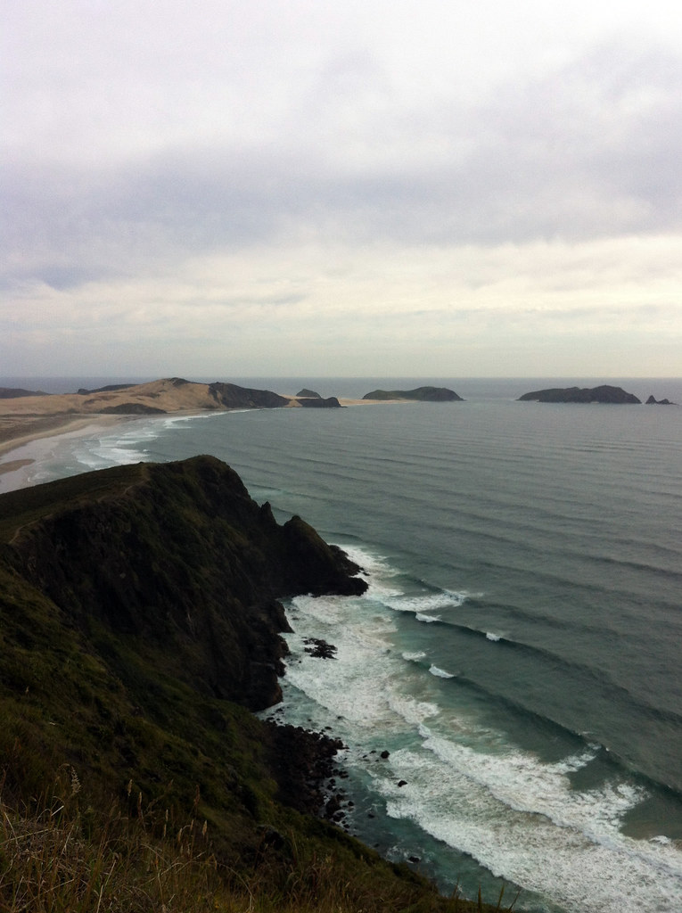 |
| Maria Van Diemen Land (the westernmost point of New Zealand) as seen from Cape Reinga |
I cannot imagine what it would be like to visit Cape Reinga when the parking lot is full of tour buses because it is such a spiritual place, I imagine the vast number of people crowding the point would ruin its serenity. Fortunately, the night I visited, there were only a handful of tourists. It was so peaceful and quiet, the only sounds being those of the waves crashing on the rocky coast below, a few sea birds, and the wind blowing through the grassy hillsides. The air was warm and comfortable and you could see the turquoise waters of the Pacific merging with the darker waters of the Tasman off the coast where a thin band of mixing water left a visible stripe a good distance off shore. To the west, clear views out to the long beach leading to Maria van Diemen's Land and the rocky hills marking the western most point of NZ. Off the point of Maria van Diemen's Land are a few more grass-covered islands, and a good distance from land to the north is another little archipelago called, Manawa Tawhi - or Panting Breath. A Maori chief once swam to those islands from the main land, naming them for his physical state upon arriving. While no one lives out there now, Maori people lived there until about 200 years ago! What an existence that must have been!
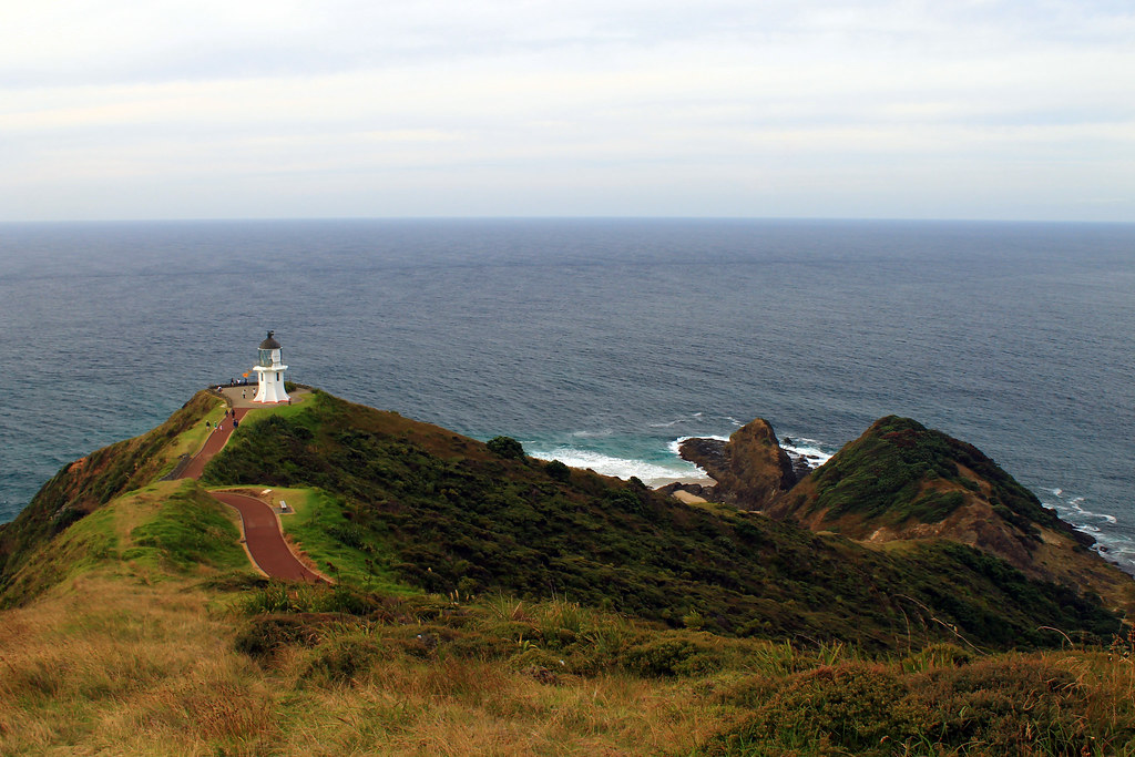 |
| Cape Reinga Lighthouse and Te Reinga below. The dark line near the horizon is the mixing line between the waters of the Tasman Sea to the west (left) and the Pacific Ocean to the east (right) |

No comments:
Post a Comment